Wayne County, West Virginia Cemetery Listings-Volume 5
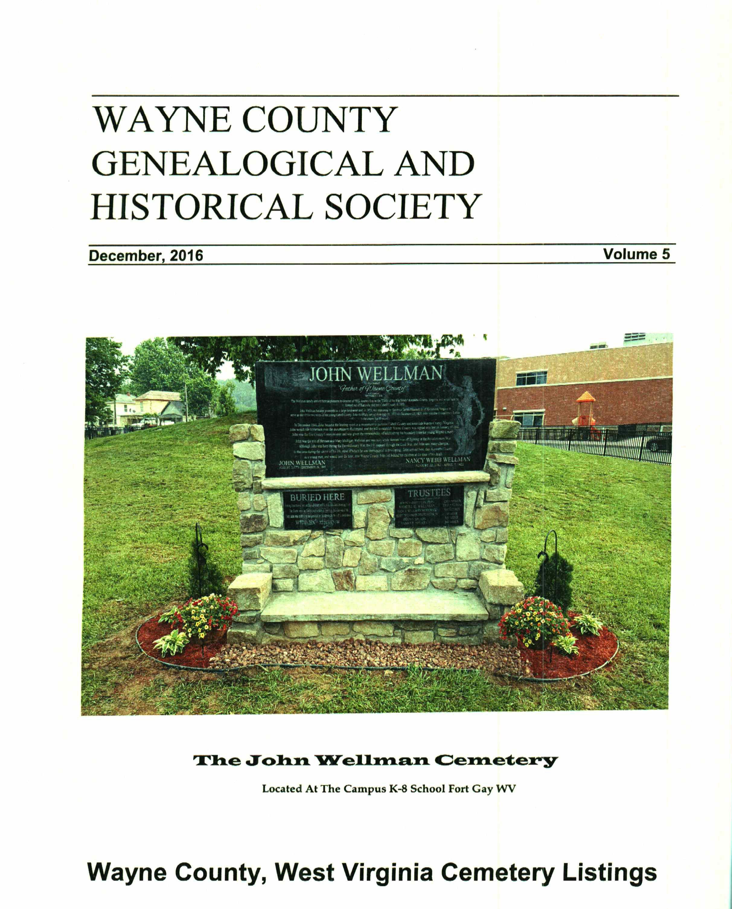
The John Wellman Cemetery
FATHER OF WAYNE COUNTY
Located At The Campus K-8 School Fort Gay WV
GPS 38 06'53.65n 82 35'32.46w
8
2016 Wayne County Genealogical And Historical Society, Inc.
No part of this book may be reproduced in any format, nor posted to any electronic forum without express permission of this society.
Additional copies of this book may be obtained from
Wayne County Genealogical & Historical Society
P. O. Box 787
Wayne, West Virginia, 25570
Price: $28.00 Postpaid
Cemetery Book V Table Of Contents
Adkins Cemetery Located on Little Lynn Creek, near home of Larry Pratt.
Gordon Adkins Cemetery Located at head of Raccoon Ck. off Beech Fork. - GPS N 38deg 14min 05.6sec W 082deg 17min 14.5sec
Everett Adkins Cemetery GPS N 38deg 13min 41.6sec W 082deg 17min 38.9sec
Akers Cemetery Located below Hensley Br. of Whites Ck., first house, turn right. - GPS N 38° 17.738' W 082° 31.185'
Alley Cemetery Located on old Wade Alley farm on Centerville Rd. - GPS N38 deg 14.972 min W082 deg 32.231 min
Alley-Miller Cemetery Located on Whites Creek, right side. - GPS N 38 deg 17.423 min W 082 deg 32.532 min
Booth-Staley Cemetery Near mouth of Whites Ck. Also has adjoining Collins Cemetery.
Canterbury Cemetery Located on Rices Branch, about 200 feet from intersection to Whites Ck. - GPS N 38º 17.813' W 082º 32.112'
Christian Cemetery Located near the mouth of Wolf Creek.
Mariah Clark Cemetery Located across 12 Pole from East Lynn Post Office.
Cole Cemetery Located 2.8 miles South of VA Hospital on Spring Valley Drive.
Collinsworth Cemetery Located above Hensley Br. of Whites Ck., right side, top of hill.
Cox Cemetery Located head of Billy’s Br., top of hill to the left.
Upper Cox Cemetery Located on Lycans Ridge, near Billy’s Branch.
Crockett Cemetery Located at the mouth of the middle fork of Wilsons Creek.
Cyrus Cemetery Located up Whites Ck on Darrell Wellman Farm. - GPS N 38
° 17.453" W 082° 32.564"Abraham Cyrus Cemetery Located above mouth of Whites Ck., right side of Tolsia Hwy. - GPS N 38° 17.862' W 082° 34.625'
Samuel Cyrus Cemetery Located on RF of Wilsons Creek.
William Cyrus Cemetery Located just south of mouth of Whites Ck. Rd., first Rd to left.
Davidson Cemetery Located at Nestlow, near junction of Four Mile & Beech Fork Rds.
Roscoe Davis Cemetery Located on Napier Ridge.
Dickerson-Fortner Cemetery Located near mouth of Newcomb Cr., home of Lauren Michaels.
Ferguson-Hatten Cemetery Located near junction where Rt. 75 turns toward Tolsia Hwy.
Jasper Ferguson Cemetery Located on the left fork of Big Lynn Creek.
Francis Cemetery Located on Montgomery Ridge Rd., head of Mill Creek Rd.
Lando Gilkerson Cemetery Located on Beech Fk. Rd., just above mouth of Wolf Pen. - GPS N 38 13 0 W 082 17 22
Hamilton Cemetery Located near junction of Mill Creek and Tolsia Hwy.
Hatfield Cemetery Located behind Peters Chapel, two miles south of Fort Gay.
Wiley Hatten Cemetery Located off Big Sandy Rd., across from Novamont.
Hazlet Cemetery Located on Thacker Ridge Rd. - GPS N 38° 17.326' W 082° 33.764'
Hensley Cemetery Located below Hensley Br. of Whites Ck., first house, turn right. - GPS N 38° 17.563 W 082° 31.596'
Jones Cemetery Located at head of RF Little Lynn Ck., on left side of road.
Justice Cemetery Located on Lycans Ridge, end of Brush Creek Rd.
Kennedy Cemetery GPS: N 38 deg 23 min 16.49 sec W 82 deg 31 min 08.51 sec
King Cemetery Located on Little Lynn Ck.
Lucas Cemetery Located off Napier Ridge, left fork of Big Lynn Creek.
Luther-Bowen Cemetery Located on Brumfield Ridge Rd.
Luther-Stephenson Cemetery Located on Brumfield Ridge Rd.
Lycans Ridge Cemetery Located on Lycans Ridge, near junction with Brush Creek.
McComas Cemetery Located one mile up Hurricane Cr., top of hill above church.
McKeand Cemetery Located near Walker Br. Rd., across from gas compressor station.
Guy Miller Cemetery Located head of Simpkins Br. of Beech Fork Ck. - GPS N 38 deg 14min 6.5sec W. 082 deg 17 min 28sec
Moore Cemetery Located on Montgomery Ridge Rd., head off Mill Creek Rd.
John Napier Cemetery Located on Napier Ridge, head of Big Lynn Cr.
Maryland Napier Cemetery Located one mile past Edgar Napier Cemetery.
Robert Napier Cemetery Located at East Lynn, past fire department. - GPS N 38 10.60' W 082 23.11'
Walter R. Osburn Cemetery Located at East Lynn, across swinging bridge to left.
Unknown Perdue Cemetery Located on RF of Rices Branch of Whites Ck.
Rev. Lewis Peters Cemetery Located behind Peters Chapel, two miles south of Fort Gay.
Josiah Philpott Cemetery Located on Sunnyside Rd., two miles south of Fort Gay.
Rice Cemetery Located on Montgomery Ridge Rd., head off Mill Creek Rd.
Shy-Gilkerson Cemetery Located 1/4/miles below Centerville. - GPS N 38° 16.620 W 082° 31.797'
Smith Cemetery Located at head of Rice’s Branch, off Whites Ck. Rd.
Harrison Smith Cemetery Located up Whites Ck., past Damron Br. Rd., .1 mile, across creek - GPS N 38° 14.549' W 082° 30.332'
John B. Smith Cemetery Located on Rock Lick Branch of Whites Creek. - GPS N 38° 16.351' W 082° 32.929'
William J. Smith Cemetery Located on Centerville Rd., across bridge, turn right on first road. - GPS N 38 deg. 15.622 min. W 082 deg. 31.901min.
Wade Spence Cemetery Located on Lycans Ridge, near junction with Billy’s Branch.
Walter Staley Cemetery Located up Whites Ck. Turn right on Walter Staley Rd. - GPS N 38° 17.672' W 080° 32.548'
Stephens Cemetery Located RF of Little Lynn Cr.
Stephens-Stevens Cemetery Located in head of Right Fork of Wilsons Creek. - GPS N 38º 12.502' W 082º 22.852'
Stevens Cemetery Located below Hensley Br. of Whites Ck., first house, turn right. - GPS N 38° 17.563 W 082° 31.596'
Stiltner Cemetery Located near junction of Napier Ridge & LF of Big Lynn Ck.
Strother Cemetery Located at top of hill at mouth of Big Hurricane Ck.
Stroud Cemetery Located at Wilsondale.
Thacker Ridge Cemetery Located last house up Thacker Ridge Rd., top of ridge to left. - GPS N 38° 16.772' W 082° 33.522' Elev. 984'
Wilkinson Cemetery Located at Rolling Hills Subdivision, Dickson.
Wilkinson Cemetery Located in Wayne, near Mike Ferguson home. - GPS N38º 10.672’ W082° 15.904’
William Walker Cemetery Located south of Wayne on old Twelve Pole Creek Rd.
Williamson Cemetery Located off Two Mile Creek Rd.